The following map shows the extent of normal high tide waters should the North Pool dike be breached.
The Hellcat wooded swamp and trail would be inundated by normal high tides.
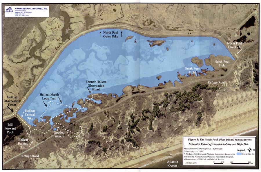
A Summary Report and map produced by Normandeau Associates, Inc, an environmental consulting firm engaged by the refuge, shows that removing a portion of the dike and allowing an unrestricted normal high tide into what is now the North Pool (which is the proposal being put forth) will cause tidal inundation of much of the current Hellcat swamp along the west side of the road. This will immediately kill all of the woody vegetation in this area. In several places, including near the Goodno Woods crosswalk, the tides will nearly reach the road itself. In addition, much of the field south of the North Pool Overlook in the vicinity of the stone boundary marker will be inundated during normal high tides. Astronomical storm tides will be much higher still.
The North Pool Impoundment provides a very important buffer between the salt-water Plum Island Sound and the Hellcat fresh-water water table. The Hellcat Swamp thickets and Maritime forest, and grass meadows, provide critically important feeding and resting sites for the full gamut of neotropical migrant landbirds, including flycatchers, vireos, thrushes, warblers, and Bobolinks.
Even if (at further expense) a second protective dike is created surrounding the immediate perimeter of the Hellcat Swamp woodland, we fear that the freshwater aquifer necessary to support these woodlands may be compromised by the intrusion of salt water, especially during a storm surge of salt water during an astronomical high tide, which may then still severely damage the Hellcat Swamp woody vegetation.